
The following is an excerpt from Great Plains Weather by Kenneth F. Dewey, the latest edition to the Discover the Great Plains Series, available now.
Where, Exactly, Is Tornado Alley?
The term “Tornado Alley” was first used in 1952 by U.S. Air Force meteorologists Major Ernest J. Fawbush and Captain C. Robert Miller as the title of a research project to study severe weather in parts of Texas and Oklahoma.

However, defining the exact geographic area of Tornado Alley is similar to trying to define the exact geographic limits of the Great Plains. Many Tornado Alley maps have been created over the years. Most maps outline the region from northeast Texas up through Nebraska and slightly east into Iowa as Tornado Alley. There are maps showing the geographic extent of Tornado Alley extending further north up into the Dakotas, and some maps extend Tornado Alley out of the Great Plains to the east into Illinois and Indiana. This definition does ignore the high frequency of tornadoes across the Gulf States into Florida. I have seen the phrase “Dixie Alley” used to describe this second area of high tornado frequency, but it has never stuck with the public or the media, and instead when they hear Tornado Alley, they automatically think of the Great Plains region from Texas to Nebraska.
These two Tornado Alleys become obvious when looking at the tornado data. The Storm Prediction Center maintains an archive of all verified tornado occurrences since 1950. Looking at the most recent thirty-year period (1987–2016) the annual average tornado frequency for each state was standardized using a scale of number of tornadoes per 10,000 square miles. The top thirteen standardized tornado frequencies include the following:
Traditional Tornado Alley, into the Midwest:
Kansas: 11 tornadoes per 10,000 square miles
Illinois: 10 tornadoes per 10,000 square miles
Oklahoma and Iowa: 9 tornadoes per 10,000 square miles
Nebraska and Indiana: 7 tornadoes per 10,000 square miles
Dixie Alley:
Mississippi, Florida and Alabama: 10 tornadoes per 10,000 square miles
Louisiana, South Carolina, Tennessee, Arkansas: 8 tornadoes per 10,000 square miles
These numbers illustrate that the tornado frequency peak is spread out not only across the classic Tornado Alley but also into the region off to the east and southeast as well.

The map in figure 49—with 13,454 tornadoes mapped for a recent ten-year period—illustrates that tornadoes in the conterminous U.S. are active not only within the traditional Tornado Alley region in the Great Plains but also throughout the Midwest and across the Gulf States. It appears that the attribution of the phrase Tornado Alley for the Great Plains region is more of a convenience than an indication that there is a disproportionate share of tornadoes out on the plains.
There may not be much of a difference in the frequency of tornadoes on the Great Plains compared to the Midwest or Dixie Alley regions, but there are some unique characteristics of the Great Plains (Tornado Alley) tornadoes that set them apart from the rest of the country.
Unique Characteristics of Great Plains Tornadoes
The Storm Prediction Center tornado-fatality data archive for a recent thirty-year period, 1987–2016, shows us a higher incidence of tornado fatalities in Dixie Alley—Arkansas, Mississippi, and Alabama—as compared to the traditional Tornado Alley states of Oklahoma, Kansas, Nebraska, and Iowa. Using this data archive, I moved a 325-mile-by-325-mile (102,000 square miles) grid cell around the regions of Tornado Alley and Dixie Alley. The difference in tornado fatalities was dramatic.
For example, when this grid cell was centered on latitude 39° north, longitude 98° west (center of the traditional Tornado Alley), there was total of 2,885 tornadoes with 69 fatalities and 1,123 injuries. However, when I centered this same-sized grid cell for the same time period at latitude 33° north, longitude 89° west (center of the Dixie Alley), there were 2,276 tornadoes with 502 fatalities and 6,604 injuries. The lesson uncovered by these data is that tornadoes are far less deadly in the plains states.
The same 102,000-square-mile grid cell in Dixie Alley had 22 percent fewer tornadoes (2,276 tornadoes compared to 2,885 tornadoes) but 728 percent more fatalities (502 fatalities compared to only 69 fatalities) and 588 percent more injuries (6,604 injuries compared to 1,123 injuries). This increased fatality rate and injury rate is not the result of a higher frequency of tornadoes across these southern states, so there must be something else causing this difference.
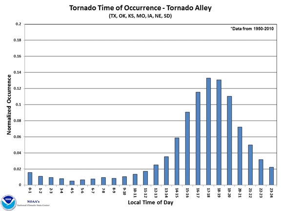
afternoon and early evening hours. Courtesy of NOAA.
Dr. Walker Ashley, a Northern Illinois University climatologist and geography professor, compiled data on killer tornadoes from 1880 to 2010 and discovered that the Mid-South has the deadliest tornadoes. “The country’s most vulnerable region for tornado-related fatalities and killer tornado events basically stretches from Little Rock (Arkansas) to Memphis to Tupelo (Mississippi) to Birmingham (Alabama),” Ashley said in an NIU press release.
There are two primary factors that help explain the higher fatality rate in these states and the lower fatality rate in the Great Plains: tornado diurnal distribution and tornado seasonality. There is a stark contrast in the diurnal timing of tornadoes between the Great Plains Tornado Alley and the southeastern U.S.
In contrast to the Tornado Alley states, many of the tornadoes in the southeastern and Gulf States occur during the night (nocturnal). The percentage of nocturnal tornadoes is
the highest in Tennessee with 45.8 percent of their tornadoes occurring at night. Joining Tennessee at the top of the list are Arkansas, 42.5 percent; Kentucky, 41.5 percent; and Mississippi at 39.6 percent of their tornadoes occurring at night. In contrast, Texas to Kansas averages 24 percent to 32 percent of their tornadoes at night, and Nebraska to North Dakota only 16 percent to 24 percent (see figure 50).
Only 27 percent of all tornadoes in the United States occur at night, but 39 percent of all tornado fatalities and 42 percent of killer tornado events happen at night. Ashley and two other NIU researchers determined that nighttime tornadoes—those occurring between midnight and sunrise—are 2.5 times more likely to take lives than daytime twisters. It’s easy to understand that tornadoes in the middle of the night catch residents off guard and therefore are more deadly.
Since I live in Nebraska, I have archived and digitized all of the tornado records for the state. Nebraska’s tornado climatology provides an excellent example of how diurnally concentrated tornadoes are on the Great Plains. A total of 2,821 tornadoes are documented for Nebraska between 1950 and 2016. A total of 56 percent of Nebraska’s tornadoes have occurred during the four hours between 4:00 p.m. and 7:59 p.m. and 76 percent of Nebraska’s tornadoes have occurred during the six hours between 3:00 p.m. and 8:59 p.m., with relatively few occurring after midnight. This diurnal distribution of tornadoes, standing in stark contrast to the southeastern U.S., is common throughout the plains.
Read more about Great Plains tornadoes and other weather patterns in Great Plains Weather.
